Fail:WestAfrica1625.png
Rezolushyon a̱ lan ma̱ng shi nshyia̱ bah.
WestAfrica1625.png (A̱yaapixel 498 × 306, shi fail: 31 KB, kak MIME: image/png)

|
This historical map image could be re-created using vector graphics as an SVG file. This has several advantages; see Commons:Media for cleanup for more information. If an SVG form of this image is available, please upload it and afterwards replace this template with
{{vector version available|new image name}}.
It is recommended to name the SVG file “WestAfrica1625.svg”—then the template Vector version available (or Vva) does not need the new image name parameter. |
Nam-a̱lyiat
| Wa̱i a̱lyiat |
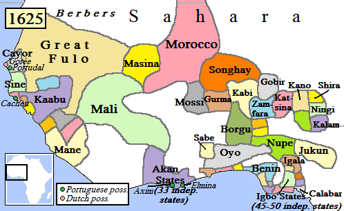
English: Map of West Africa, AD 1625.
(Partially based on Atlas of World History (2007) - Early modern Africa, map.) |
| A̱tuk | |
| A̱tyin | Ta̱m a̱pyia̱ nung hwa |
| A̱tyulyuut | Gabagool |
Shyiat kwaa̱mbwat a̱ka̱wat
I, the copyright holder of this work, hereby publish it under the following license:
Á̱ nwuak fail huni a̱tafa kwambwat a̱ka̱wat Creative Commons A̱di̱dam Kaswuo 3.0 Unported hu hwa.
- A byia̱ sa̱t:
- ka̱ a cat ka̱u – ka̱ a cat maat, ka̱u ma̱ng shei ta̱m hu
- ka̱ a cat nyia̱ ri̱mik – ka̱ a cat saai ta̱m hu
- A̱tafa ta̱fwat ji̱ khwi a̱ni:
- a̱di̱dam kaswuo – Ta hwa a nwuak a̱gwai ku myim a̱ni, tyia̱ a̱fwuop kwaa̱mbwat a̱ka̱wat ka, a si̱ wa̱i ka̱ á̱ ku shai kyang mami. A bye nyia̱ a̱nia di̱ kuzang za̱kwa ji̱ myim a̱ni, a̱wot tyong nyian hu si̱sak ji̱ na li á ngyei a̱tyunwuat kwaa̱mbwat a̱ka̱wat wu wa shim ang ku da̱ nggu wa shim nyian ta̱m ang hu a̱ni.
Nkhang fail
Nyap a̱tuk/jen a nwuan fail hu ma̱nang ku ku ndi di̱ ntsa hu mi̱ di̱n jen a̱ja.
| A̱tuk/Jen | A̱gban ghwughwu | Shi-a̱ka̱ta̱m | A̱tyunta̱m | A̱di̱dam | |
|---|---|---|---|---|---|
| mi̱ di̱ yong huni | 18:42, 5 Zwat Tswuon 2010 | | 498 × 306 (31 KB) | Omar-Toons | Reverted to version as of 00:15, 16 June 2009 |
| 19:05, 20 Zwat Nyaai 2010 |  | 497 × 306 (31 KB) | Bokpasa | Saadi dynasty and Tuaregs | |
| 01:15, 16 Zwat A̱taa 2009 |  | 498 × 306 (31 KB) | Gabagool | rm lines | |
| 20:57, 19 Zwat Nyaai 2009 |  | 498 × 306 (32 KB) | Gabagool | {{Information |Description={{en|1=Map of West Africa, AD 1625. (Partially based on ''Atlas of World History'' (2007) - Early modern Africa, map.)}} |Source=Own work by uploader |Author=Gabagool |Date=2009-04-19 |Permission= |other_versi |
Nyian ta̱m ma̱ng fail
Wat huni nyia̱ ta̱m ma̱ng fail huni:
Nyian ta̱m ma̱ng fail mi̱ swanta hu a̱mgba̱m
A̱yaawuki á̱ghyang bani nyia̱ ta̱m ma̱ng fail huni:
- Nyian ta̱m di̱ af.wikipedia.org
- Nyian ta̱m di̱ als.wikipedia.org
- Nyian ta̱m di̱ ar.wikipedia.org
- Nyian ta̱m di̱ azb.wikipedia.org
- Nyian ta̱m di̱ bn.wikipedia.org
- Nyian ta̱m di̱ ca.wikipedia.org
- Nyian ta̱m di̱ da.wikipedia.org
- Nyian ta̱m di̱ de.wikipedia.org
- Nyian ta̱m di̱ en.wikipedia.org
- Mali Empire
- Songhai Empire
- Songhai people
- Sahelian kingdoms
- Oyo Empire
- History of West Africa
- Islamization of the Sudan region
- Kaabu
- Empire of Great Fulo
- Dendi (province)
- Legends of Africa
- Timeline of Nigerian history
- List of kingdoms in Africa throughout history
- Military history of the Mali Empire
- Nigerian traditional rulers
- User:OnBeyondZebrax/sandbox/African history
- User:Tisquesusa/sandbox9
- The Songhai
- Medieval and early modern Africa
- Nyian ta̱m di̱ en.wikibooks.org
Li nvak jhyang nang á̱ nyian ta̱m mi̱ swanta hu ma̱ng fail huni.