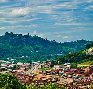
Si̱tet Ikiti
Ikiti Sitet yet sitet min a̱tak jenshyun Nijeriya, a̱ shi di̱ gak Kwara Sitet a̱tyin a̱za a̱ni, Kogi Sitet din a̱za atyin, min a̱tak min a̱za atyin yet Ondo Sitet, min a̱tak a̱ni, Osun Sitet. A nwak á̱lyoot Ikiti ku myim a̱niet Ngwang kpang ba nang ba shie a̱kpa a̱ni di̱ sitet ji a̱ni. A yei Agbandang keyang sitet ji Ado-Ikiti.[3]
| Kpaat | 1 Zwat Swak 1996 |
|---|---|
| A̱lyem a̱gwomna̱ti | Shong |
| Vam-a̱byin | Afrika |
| A̱byin | Naijeriya |
| A̱keangtung | Ado Ekiti |
| Shyia̱ di̱ fam tyok a̱byin | Naijeriya |
| Shyia̱ di̱ fam jen | UTC+01:00 |
| Coordinate location | 7°40′0″N 5°15′0″E |
| Ofit wu nang a̱kwak a̱son a̱gwomna̱ti wu ba̱ng a̱ni | Governor of Ekiti State |
| Sa a̱pyia̱ a̱gwomna̱ti | executive council of Ekiti State |
| Sa kpa cam a̱byin | Ekiti State House of Assembly |
| Nyian tyok tazwa | Fountain FC |
| Byia̱ (a̱gi̱)gak ma̱ng | Si̱tet Kwara, Si̱tet Kogi, Si̱tet Ondo, Si̱tet Oshun |
| Ci̱t | Si̱tet Ondo |
| Official website | https://www.ekitistate.gov.ng/ |
| Sa mat tá̱si̱la | Category:Maps of Ekiti State |

Ikiti sitet yet lamba swak ntat min nyung di̱n tyan swuo kpop, a yet lamba swak ntat min shyi á̱niet. A byie a̱niet cii kop ncii kop tsat min cii kop tsat(3.3m) min 2016.[4] Ikiti sitet shyie a̱ka̱watyie susop Naijeria min a̱za a̱won asi byie a̱ya nzeam min nyak ayit min aya a̱kaguk. A̱si byie á̱yaa nzeam ayay Nigeria-Cameroon chimpanzee. Ba bwat swak nfeang kakap min sop a̱kakwon a̱gwamnati, Ise.[5][6] Mami zwat tsat min 2022, Ikiti sitet wa yet a̱kwak a̱son min kyiak lamba nyung ma a̱kakwon na a̱ yet kwanbwat sitet ji. Gwamna Kayode Fayemi wa shyai á̱niet a̱ tuk mam Sop a̱kakwon min swanta hu min 2022. Obeche (Triplochiton scleroxylon) biye tsatsak yet min akeyan ba ka
owing to its local prominence and environmental, economic and cultural significance.[7]
Modern-day Ekiti State has been primarily inhabited for centuries by the Ekiti people, a Yoruba subgroup, with minorities of the Akoko Yoruba subgroup. Religiously, the majority of the state's population (~85%) are Christian with smaller Muslim and traditionalist minorities at about 10% and 5%, respectively.
In the pre-colonial period, the area that is now Ekiti State was at various points ruled by the Oyo Empire, Benin Empire, and finally, the Ekiti states which formed the Ekiti Confederacy in the later half of the 1800s. From 1877 to 1893, the Confederacy fought the Kiriji War led by Fabunmi Okemesi alongside other Eastern Yoruba groups against the Ibadan Kingdom and other Western Yoruba groups; the war ended in a British-brokered stalemate before the area was colonized and incorporated into the British Southern Nigeria Protectorate which later merged into British Nigeria in 1914. After independence in 1960, the area of now-Ekiti was a part of the post-independence Western Region until 1967 when the region was split and the area became part of the Western State. In 1976, the Western State was split and the state's east became Ondo State. Twenty years later, Ondo State's northwest (then termed the Ekiti Zone) was broken off to form Ekiti State.[3]
Economically, Ekiti State is partially based around agriculture, mainly of yams, rice, cocoa, and cassava crops. Key minor industries are logging and tourism. Ekiti has the joint-thirteenth highest Human Development Index in the country and is considered the heart of the homeland of the Ekiti people.[8]
